

Today its villages are deserted and only in the summer months, they have life. The Holy Monastery of Panagia Eloni is the connecting link between Elos and Parnonas, as the name of the Monastery derives from the name of Elos.
Parnonas has several more high peaks with an altitude of over 1700 meters, such as Psari, Profitis Elias, Gaitanorrachi and Korombilia, as well as the lower Koulochera.
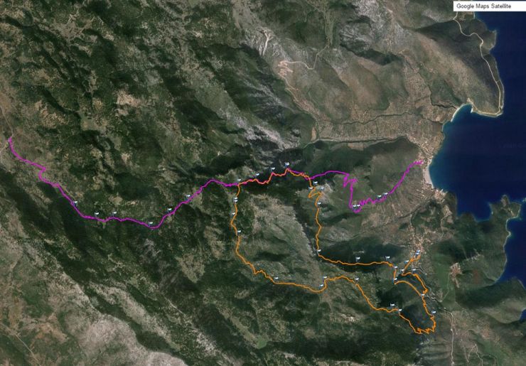
Mountain trails: 7
Routes in Kyparissi 2. No. 6 and No. 7
Routes in PARNONA - High. 1934 m.
Prefecture: Arcadia
Mountain Destination Points Archives (Waypoints)
Set of Points Waypoints: 85
Destination Points Archive GPS Exchange (GPX): Parnonas.gpx ![]()
Destination Points Archive OziExplorer (WPT): Parnonas.wpt![]()
Destination Points Archive GoogleEarth (KML): Parnonas.kml ![]()
Destination Points archive with all Routes: Parnonas_total.kml ![]()
|
Διαδρομές στο βουνό: 7
|
|
7 |
|
Snow Moiuntain: Kremasti - Kyparissi x2 |
|
Length: 12257 m. |
From the asphalt 2-3 km after Kremasti, we follow a dirt road for about 40 minutes until the end in a corral. Its continuation is on a path that moves uphill to a large pit. And we continue until the intersection with the X1 that goes to Lambokampos. From there the path becomes very wide, stone-built, and in very good condition. It moves in a rich fir forest, the southernmost in Europe, and passes through the base of impressive slopes.
Along the way, we meet an intersection with the X4 that goes to the plateau of Babala. After about 2 hours we reach the church of Ag. Barbara, where the X5 path to Paleochora starts on the right. We continue straight on the very wide path that traverses to a col with a view to all three settlements of Kyparissi.
With zig-zag and large traverse, we reach a large sheepfold, where the path ends and from the dirt road we reach the beach. The whole route is very well marked with elegant signs and minimal signs, where they are really needed. Personally, this is one of the most beautiful hiking trails in Greece.
Route recording: Dimitrakis Giannis
7 |
|
Snow Mountain: Kyparissi - Paliochora - Ag. Barbara - Babala - Kyparissi |
|
Length: 16759 m. |
Parnonas.Xionοbouni-Kiparisi-Palioxora-Ag_Barbara-Kyparisi.gpx Parnonas.Xionοbouni-Kiparisi-Palioxora-Ag_Barbara-Kyparisi.plt Parnonas.Xionοbouni-Kiparisi-Palioxora-Ag_Barbara-Kyparisi.kml |
It is a long route with huge aesthetics, which passes through the most beautiful and impressive places on the east side of the mountain. It combines the paths of 3 routes, X5, X4, and X3.
We start from the characteristic sign 100m after the gorge of Panagia ton rock. Traversed in 15 minutes we reach the intersection of paths. Right to Paleochora and Ag. Barbara with the X5 and on the left the X3 for Harakas and X4 for Babala. So we go to the right and moving in a belt with slabs we cross a ravine with a well, where we can get water and soon we reach the church of Pr. Ηλία. The path ascends a little, passes a little above the abyss of Babola, which is located inside a house built like a bus stop (!).
Soon, we pass through rocky doors and descend to high vegetation until the next ravine, under impressive slopes with caves. We continue traversed and after 1.30 from the beginning, we reach an intersection with a branch of X5 coming from the sheepfold. We continue a little uphill to some caves and ascend more intensely to the characteristic cross, which marks the emptiness of the defenders of Paleochora against Ibrahim.
After passing the ruins of the old settlement we go out to the rocky gates and go to the northern slope for this and the vegetation changes radically. The path is very wide and moves traversed in a dense fir forest up to Ag. Barbara. From there we continue uphill to the famous cobbled path and after 30 minutes we meet the intersection of X4.
There is a plain column from where the sign is missing (!). The path is clean and moves next to a small ravine to a large pit with a sheepfold. The path continues in the old fields and goes up a little further until a demolished farmhouse. From there it needs attention because in many places it is not very obvious and the signage is minimalist. With a little care and experience, however, we do not lose it. Slowly the path becomes very clean and descends into a large pit with impressive rock towers. Passing between them we descend to a larger lake - plateau and the church of Ai Giannis.
Continuing we pass through the old fields and farmhouses of Babala until we reach the impressive rock doors. 5 minutes later we are under a huge steep slope crossed by a wide belt. These are the most impressive points of the route. The path follows the belt and our eye goes to the plates of the climbing routes and the thought of the possibility of opening endless routes up there.
At the end of the belt, the path descends with several zig-zags and large traverse to the point where we separated 4.30 hours earlier. From the same, we return to the asphalt and from the horseshoe of the gorge we leave the asphalt and we take the old path of the mills that in 10 minutes take us to the square of the settlement of Vrysi.
Route recording: Dimitrakis Giannis
Source: www.hellaspath.gr