

Kyparissi is a beautiful secluded village, on the east coast of the Peloponnese between Leonidi (North) and Monemvasia (South). The village is about 4 hours and 30 minutes from Athens. In fact, it was isolated from the rest of Greece until 1970, when it was connected by road to Sparta. In the old days the access to the village was possible only by a path from the mountain or by boat from Piraeus. In fact, in 2002 the ferry connection was interrupted and only the difficult road from Sparta remained, the last ten kilometers of which are breathtaking even for climbers, as they pass between rocky slopes with continuous cliffs lurking at the edge.

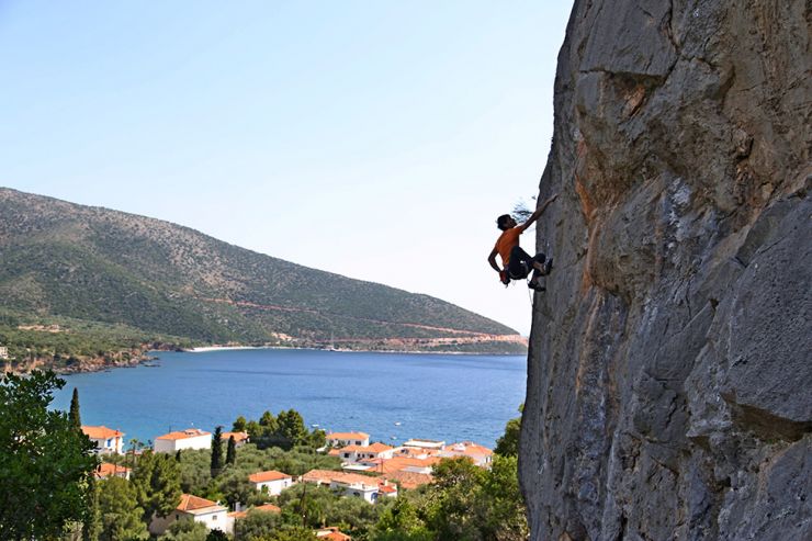
ANGY EITER ON THE MOUGARAS 6A + 25M ROUTE, IN THE NEW FIELD ‘KASTRAKI’ ABOVE THE SETTLEMENT BEACH OF KYPARISSIA. PHOTO: ARIS THEODOROPOULOS.
Kyparissi is crowned around continuous rock zones, some rather exaggerated describe it as 2-3 Céüse or as half Kalymnos, gathered amphitheatrically above the beautiful village and the sea.
A very important project started to be implemented last spring (2015) in Kyparissi: the creation of about 120 new climbing routes, which are expected to be a pole of attraction for climbers, mainly in spring and autumn. The goal is, in the first phase, to attract 20-50 climbers to the area on an almost permanent basis during the spring and autumn months, something that will positively change the physiognomy of Kyparissi, giving life to the usually deserted roads these seasons and work in all relevant companies. In neighboring Leonidio, climbing tourism has already begun to have a particularly positive impact on the local economy, while the direct connection of the two areas with the new road will contribute spectacularly to the mobility of climbers. The creation of the climbing fields is implemented with his team, the mountain guide Aris Theodoropoulos (climbgreece.com) in collaboration with the Municipality of Monemvasia and the Bodosakis bequest. (bodossaki.gr).
In addition to the routes we publish below, new fields and new routes are expected to be created!
YANNIS TORELLI ON THE SMOOTH WALL OF KOTSIPETROS 6B 25M.
PHOTO: ARIS THEODOROPOULOS.
Access to Kyparissi:
The shortest route (295 Km) leads to Corinth, Tripoli, and Sparta, where shortly before entering the city we turn left on the river Evrota. Continuing our route through the Municipality of Therapnon, we find the villages of Platana, Skoura, and Goritsa, where there is the only pharmacy in the area. After Agios Anargyros, in Geraki we turn right towards Alepochori, which is the last village of the Municipality of Therapnon and we follow the signs to Molaous - Monemvasia. Arriving at Agios Dimitris we continue left to Kremasti and about 2 Km before entering the village, on a side road we turn right. We drive to the church of Agios Konstantinos, which is located outside the village of Lambokampos and we turn left. We pass outside the village of Pistamata and finally the village of Harakas. Immediately after Harakas, the beautiful view of the area of Stavros that takes your breath away with steep cliffs and a narrow road to Kyparissi.
Coordinates: 36.972558,22.990644
Access from Leonidio: if you prefer asphalt you will head to Kosma Geraki, and then the villages - Agios Dimitrios - Kremasti - Lampokampos - Harakas - Kyparissi. A total of 97KM. If you do not mind a little dirt road of relatively good passability for a conventional car, you can shorten the route (64KM) through Poulithra - Peleta - Harakas - Kyparrisi.
The good news is that the coastal road Leonidio - Kyparissi (approximately 30-35KM) has begun construction. This road is the most difficult and important part of the Eastern coastal axis of the Peloponnese and part of the road Argos - Leonidio - Fokianos - Kyparissi, and its contractual deadline is the end of 2015.

YANNIS TORELLI IN THE COLUMNS OF THE TZABAS 7A 18M ROUTE. PHOTO: ARIS THEODOROPOULOS.
Local information
Kyparissi is an authentic village, with a unique land and island physiognomy at the same time. Built amphitheatrically, spread at the foot of Mount Parnon, it looks at the Myrtos Sea. It has three districts. First, you will find the mountainous Fountain with pines, cypresses, and firs surrounding it and many old whitewashed houses, narrow streets, flowered courtyards, and beautiful churches. After the beach, in intense Aegean color, the houses are two-story, whitewashed, with tiled roofs, blue windows, and lush gardens.
And finally, the amphitheatrically built Diocese, which is separated from the beach only by a beautiful beach! The permanent population of the village does not exceed a total of 400 inhabitants.
As you climb the rocks you really think you are on a balcony overlooking the entire Aegean Sea. You see Hydra, Spetses, and Portocheli as if they are under your feet, while on a clear day you see in the depths of the horizon and the Cyclades (Milos, Sifnos, Serifos, Kythnos, etc.) as rocks thrown in a vast blue.
The village has almost everything you need: There are many small hotels and rooms to let, taverns, 2 supermarkets, a bakery, and three cafe-bars. Do not forget to try the local traditional products: Gidotyri, touloumotyri, mizithra, goat, shrimp petoules, Gogi (local pasta), green pies on the plate, fresh seafood. Buy socks and thyme honey.
Just be careful, there is no bank or ATM and there is currently no gas station! The nearest is located at 36KM in the village of Agios Dimitrios!
CLAUDE REMY OPENING ROUTES IN THE FIELD JEROME HOUSE.
PHOTO: YANNIS METAXOTOS.
KASTRAKI
‘Kastraki’ is a new field created in the spring of 2015. It is located almost in the settlement ‘Paralia’ of Kyparissi, just above the cemetery. It is expected to become the most popular field of Kyparissi both due to its location in the village, and due to the quality climbing, it offers low and medium grades, 5c-6c.
The creators were Aris Theodoropoulos, Claude Idoux who came from Kalymnos to help, and Giannis Metaxotos from Leonidio who offered valuable help in the demanding orthopedic gardening!
The names given to the routes are the nicknames of old captains and other inhabitants of Kyparissi.
Climbing: In the left (first) section, a quality gray wall, relatively sharp but with a great variety in relief and movements. The second, upper part, "Ano Kastraki", is a negative red rock with a column and large grips. It offers dynamic, ‘gym-style’ routes. Very good dense insurance urges you not to miss the onsight!
Conditions: best autumn seasons
Access: Head to the settlement Paralia on the SE side of Kyparissi. The cemetery is located at the entrance of the village as we head towards the sea, on the right. Park near the church (opposite there is a huge parking lot in an olive grove) and head to the bridge and immediately to the right of the cemetery entrance following the well-written path between the olive trees. Walking: 5 minutes.
GPS: 36.969963, 22.991085
and spring, but also summer mornings.
Sun: In the shade in the morning. The sun hits the field after 1.30-2.00.
Orientation: SW
Routes:
ANO KASTRAKI
WATERMILL
It is the main field of Kyparissi, an impressive rock zone with a spherical red limestone with stalactites located at a characteristic turn, just above the entrance of the village.
The story speaks of the ancient city of Kifanta of Zarakas in the place of today's Kyparissi. Mythology states that in the place of these rocks, Atalanta, while hunting, thirsted and struck the javelin on the rock and gushing crystal clear water. Behind the water tanks, in small caves located at the foot of the rock, there are carved baths and rectangular niches for depositing objects or votive offerings that may be the remains of a temple of Asclepius Zeus.
It is said that until 1960, the water was abundant, so much so that it fell on the rocks next to the spring, creating small waterfalls. There are still abandoned 3-4 old stone watermills that exploited the water.
Climbing: Spherical red limestone, decorated with stalactites and columns.
Conditions: Ideal conditions on spring and autumn afternoons when the rocks are in the shade. Even in summer, after 17.00 in the afternoon, the conditions are relatively good, especially if it blows a little.
Sun: in the morning until 13.00. Orientation: NE
Access: The field is located on a large bend, 700 meters from the entrance of the first settlement of Vrysi, Kyparissi.
GPS: 36.957351,22.986013
Park, follow the path to the church, and as soon as you reach the height of the rocks, turn right.
Walking: 5 minutes.
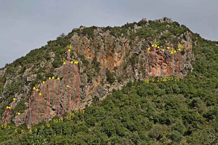
Διαδρομές:
1. Pita 4-ever 7a+ 25m
2. Kalimeralex 7a+ 25m
3. Esterattitucle 7b 25m
4. Neromylos 8? 30m
5. Zarax 8a? 25m
6. Thanks George 7a 30m
7. Jerome the gangster 7c+ 25m
8. Kyparissi 7a 20m
9. Stelios House 7b+ 20m
10. Smoke on the water 6b+ 30m
11. Sidiropoulos 6c 30m
12. No name ?
13. Trypes 7a+ 20m
14 Trypes Extension 7b 3pa 36 m
15. Koumara 6c 20m
16. Koumara Ext 7a+ 2pa 36m
17. Kyparidiso 7a 36 m wall,
18. Cave man 6c 33 m
JEROME’S HOUSE
A new field which is located near the village of Harakas, where the road begins to descend to Kyparissi. The field is not visible from the road, as it is located just below. It is a solid wall with a gray main rock. At the base of the field, there is a small cave and a wide flat belt.
At the bottom of the ravine, near the sea, is a lonely building: The house of Jerome, (John "Blackjack" Jerome), a notorious gangster and striker from the area, who lived in California at the beginning of the last century.
The field was created in March - April 2015 and bears the famous signature of the Swiss couple Claude and Christine Remy (routes 5-15). Also participating were Aris Theodoropoulos, Giannis Metaxotos (routes 1-4, and 16.17).
Climbing: Quality gray wall, with well-hidden grips, and the routes are very well secured. Unusually intense relief in the center of the field. The rock at the bottom of the tracks looks weird, but it offers impressive climbing. Ideal field for those interested in scores from 6a to 7a +.
Conditions: The field is close to the saddle and is often caught by the wind, offering cool conditions, better seasons in autumn, spring, and summer from noon onwards.
Sun: in the morning, shade after 12.00.
Orientation: NE
Access: From Kyparissi head to the village of Harakas and park at Stavros, in a parking lot on the left, just before the entrance of the village. (In front of the church of Agia Paraskevi). From there, walk backwards (towards Kyparissi) for 150 meters and go down the steep path with red signs and cuckoos. Total: 15 minutes.
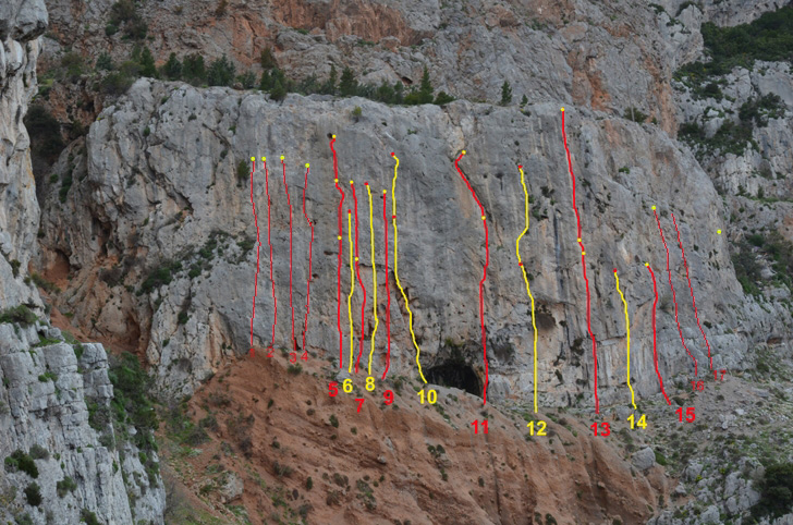
Routes:
5. ‘I kiss and punish’ 3 * 6b + 20m, Wall and small negative. The name comes from the famous Verdon route of the same name "Surveiller et punir". Also the book of the same name by Michel Foucault.
5′ Filao ke timoro Ext 3* 7a 30m, wall
΄5 ”Filao ke timoro Ext 2 3 * 7b 38m, a wall with small pads, 20 sets.
7.1 Piliza Ext 3 * 7a + 30m, Wall with small grips.
10.1 Bangsters Ext ♪ 7a + 38m, a wall with small pads, 20 sets.
11.1 The Crazy World Ext 2 * 7a + 35m, Slit, 20 sets.
12.1 Of Arthur Brown Ext 3 * 6b + 30m, Wall and slit.
13.1 Catalavenis? Ext.1? 30m, Smooth wall.
13.2 Catalavenis? Ext. 2 3 * 6c 38m, Wall with nice grips, 20 sets.
17. Cable car 2 * 5c 25m Beautiful dihedron.
BABALA

Babala is an old abandoned rural settlement located on a plateau about 2 hours above Kyparissi. In this area, locals used to live, maintaining vineyards, fields and huts with basements, where they kept the wine. Along the route of the old path to Babala there are continuous extensive rock zones ideal for countless sport climbing routes in endless columns!
The field offers stunning views of the Aegean Sea and all the settlements of Kyparissi!
There were only 5 routes opened by two French climbers who used a donkey from the village to transport the materials. Recently, Giannis Torrelis opened 15 more tough new routes in incredible columns. Also Angy Eiter together with Bernie Ruech, opened and climbed a new route of difficulty 8c!
Climbing: Kalymnos style in columns and stalactites but with very difficult presses.
Conditions: best seasons autumn and spring but even summer afternoons.
Sun: in the morning until 13.00. Orientation: NE
Access: From the exit of Kyparissi drive for about 3.2 km and park when the road becomes flat shortly after the characteristic turn, next to the sign "Welcome to Kyparissi".
GPS: 36.94876,22.995948.
Follow the railings of the old path to the large belt of rocks. Walking: 50 -55 minutes.
For the routes, we will soon have information at climbgreece.com.
DIANA MOUSES ON THE ROUTE KASTRAKI 5B + 20M, AND MEMBERS OF THE SCHOOL OF AOS ACHARNES IN THE NAME FIELD ABOVE KYPARISSI.
PHOTO: ARIS THEODOROPOULOS.
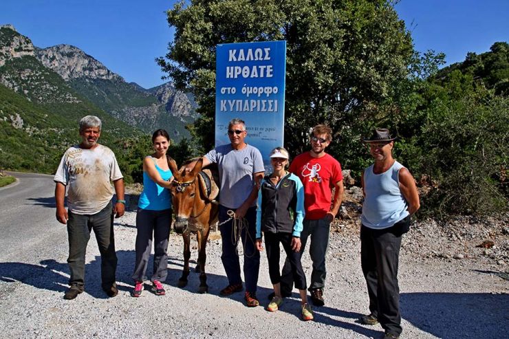
EXCITED DISTRIBUTION TEAM IN KYPARRISI: FROM THE LEFT K. MITSARAS AND HIS PATIENT MOLE, KATIE ROISSOU, giannis metaksotos, angie eyter, bernie ruech.
PHOTO: ARIS THEODOROPOULOS.
Πηγή: www.vrahomania.gr